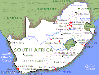
South Africa occupies the southernmost part of Africa. streching latetudinally from 22S to 35S and longetude 17E to 33E
GO ON !
Nguni 1200
Zulu (Central Nguni)
Ndebele ->
Xhosa (Southern Nguni)
Swazi
(CLICK to see groupes)
South Athlantic Ocean. The Benguela currents is could and flows northwards.
The average annual sea temperature at Muizenberg (Warm currente) is 16.6C and at Cape town Harbour (Could current) only 12,8C (CLICK)
Indian Ocean. with the Aghulhas current is warm and flows south to Cape town Harbour
Geology
Population groupes
Close Geology
Ounly real natural harbour of the 2954 coast line is Saldanha Bay.![]() Lack of fresh water made the early inhabetons use Table bay harbour
instead. (CLICK)
Lack of fresh water made the early inhabetons use Table bay harbour
instead. (CLICK)
SA has an average annual rainfall of only 464 mm. 21 per cent of of the country has a rainfall of less than 200 mm and 31 per cent more than 600mm.
Oceans
Ouldest Rocks 3800 million years
Karoo Basin covers 75 per cent of central part of South Africa, contains most of the coal resources.
The gould-bearing Witwatersrand Basin is inportant and the Ventersdorp Basin.
IRON
Venda 1700
Chrome and Platinum
Kimberlite pipes the source of SA Diamonds.
Population
_1,032,943 Asians _3,435,114 Coloureds _5,171,419 Whites 30,645,157 Africans
Welcome to the sunchine country.
Enjou this short tour of our beatiful country. You will find some interesting information on this page. Contact us at [email protected]Sotho-Tswana 1450
Sotho-Tswana 1450 (CLICK to see goupes)
East Sotho
Tswana (West Sotho)
North Sotho (pedi)
South Sotho
Tshonga 1830
netwoord | Mafikeng | North West | grass
![]()